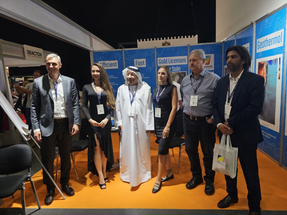
Terravox Showcases Innovation at the 2024 Dubai Mining Show
The 16th Dubai Mining Show, held under the patronage of the Ministry of Energy and Infrastructure (MoEI), brought together key industry stakeholders from across the globe. As the region’s premier mining event, it served as a hub for collaboration, featuring 150+ expert speakers, 40 panel discussions, and 200 exhibitors showcasing the latest advancements in mining technology.
Terravox was proud to be again part of this prestigious event, with our booth drawing strong interest from mining companies, license holders, and industry leaders. Our team engaged in insightful discussions about our cutting-edge GEMS technology and microseismic sounding methods, highlighting their potential to revolutionize resource exploration and extraction.
Our presence at the show reinforced our commitment to driving innovation in the mining sector and expanding our reach in the Middle East market. It provided a valuable platform to strengthen partnerships and explore new opportunities for collaboration.
We extend our appreciation to MoEI and the event organizers for creating such an impactful forum for industry growth. Terravox looks forward to returning next year and continuing to lead the way in advanced, sustainable mining solutions.
Exploring Gold Potential: A Breakthrough in Tanzania’s Ore Gold Licence
Gold exploration is entering a new era with cutting-edge geophysical techniques enhancing our ability to locate hidden resources. In the northeastern part of Tanzania, a recent project at the Ore Gold Licence demonstrates how advanced methods like GEMS (Geological Exploration Microseismic Sounding) are transforming the search for gold in challenging terrains.
Unlocking Gold Reserves at the Ore Gold Licence
Located near Ruamagaza, Tanzania, the Ore Gold Licence spans a vast 10 million square meters, making it a prime site for exploration. With the growing demand for cost-efficient exploration methods, GEMS was selected for its ability to detect potential gold deposits deep beneath the Earth’s surface, without the need for invasive drilling during the initial phases.
Preliminary assessments of the area suggested that the region’s geological history might hold promising gold deposits, stemming from past magmatic activity. The goal of the project was to identify subsurface fractures and fluid channels that often serve as key indicators of gold ore deposits.
Harnessing Advanced Technology for Gold Exploration
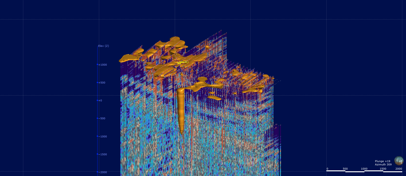
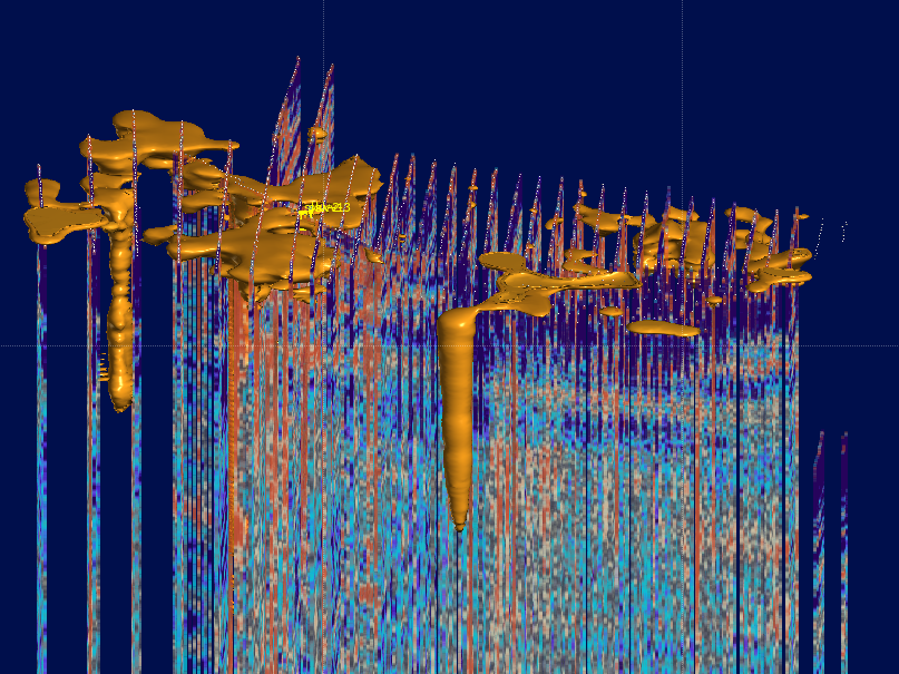
The GEMS method, known for its ability to detect subtle variations in seismic wave velocities, was applied to map the underlying geology of the Ore Gold Licence. A total of 1,690 survey points were distributed across the licence area, each recording microseismic signals for six hours. These data points helped construct a detailed 3D model of the subsurface, reaching depths of 4.5 km.
“Our focus was on identifying zones of increased fracturing and reduced seismic wave velocities, which are often associated with ore-bearing formations,” says the lead geophysicist on the project. “The GEMS method allowed us to visualize the underground structure and pinpoint areas that warrant further exploration.”
Promising Results and Interpretations
The survey delivered significant results, highlighting zones of reduced seismic wave velocities that are consistent with the presence of fractured rock and quartz enrichment—both promising indicators of gold deposits. The 3D model revealed vertical structures resembling magmatic roots, with wide zones near the surface, hinting at potential gold concentrations within these formations.
“The GEMS technology enabled us to narrow down the exploration area, allowing for more targeted drilling,” explains the project leader. “This drastically improves cost-efficiency, as we can now focus our efforts on the most promising locations.”
Challenges and Future Directions
While the initial findings are promising, the interpretation of the data presents some challenges. The presence of multiple vertical structures, while indicative of potential ore deposits, requires further investigation to confirm the extent and concentration of the gold within these zones.
The next phase of exploration will involve drilling in the identified areas to verify the presence of gold. This phase will not only provide more concrete results but will also help refine the GEMS technology for future applications in gold exploration.
The Future of Gold Exploration with GEMS
The success of the GEMS method at the Ore Gold Licence marks a pivotal moment for gold exploration. By providing a clear, detailed understanding of the subsurface, GEMS significantly reduces the time and resources needed for initial prospecting efforts.
As this technology continues to evolve, it has the potential to revolutionize exploration not just in Tanzania, but in gold-rich regions worldwide. Projects like the Ore Gold Licence demonstrate that innovative geophysical methods can pave the way for more efficient, cost-effective, and sustainable gold mining.
Geothermal Site, Taiyuan, China, 2024
Microseismic Sounding Method Tested in Taiyuan
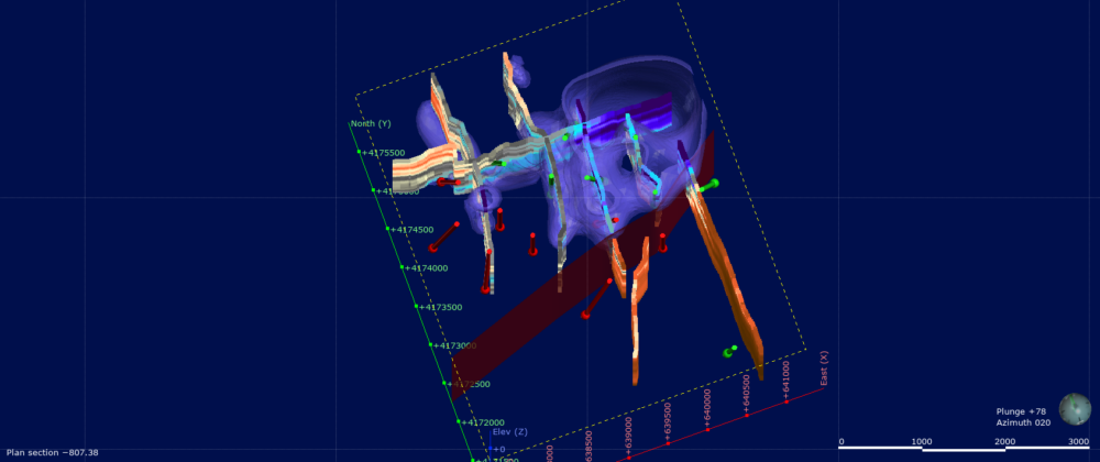
A recent study in Taiyuan, China, tested the Microseismic Sounding (MMS) Method to assess limestone permeability for geothermal exploration. Conducted by Terravox Global Limited and Sinopec Green Energy (SGE), the experiment aimed to map subsurface structures using seismic shear wave velocities.
Key Findings
- Fault Zone Detection: MMS successfully identified a buried fault zone, confirming its ability to detect deep geological structures.
- Porosity Correlation: Areas with lower seismic velocities matched higher porosity zones, validating the method’s effectiveness.
- Unexpected Productivity Results: Contrary to expectations, wells in high-porosity zones showed lower productivity, suggesting complex geological factors at play.
Conclusion
MMS proved valuable for fault and porosity mapping, but the unexpected porosity-productivity relationship calls for further investigation. This study enhances geothermal exploration methods, reducing drilling risks and improving resource assessments.
Gold License Tanzania
Kilombero – Buckreef Geita Gold Project is strategically positioned approximately 110 kilometers west of Mwanza, Tanzania’s second-largest city, and close to Lake Victoria, the world’s largest tropical lake. The geographical positioning of Kilombero – Buckreef Geita Gold Project offers logistical advantages, including proximity to key transport routes that connect the region to major urban centers and ports. Access to Kilombero – Buckreef Geita Gold Project is primarily through well-maintained rough roads that link the mining site to Geita Town, a central hub for the region’s mining activities. The area’s infrastructure has been significantly developed over the years, driven by the mining industry’s demands, making it relatively easier for companies to establish and operate mining ventures.
Tanzania gold mine, Geita District, Tanzania, 2024
Introduction
In 2023-2024, an exploration survey was conducted at the Ore Gold Licence in northeastern Tanzania, a site spanning over 10 million square meters. The survey aimed to uncover promising gold deposits using an innovative geophysical method known as Geological Exploration Microseismic Sounding (GEMS). This case study explores how GEMS technology was successfully applied to increase the precision of gold prospecting in a challenging geological environment.
Challenge
Traditional gold exploration methods often require extensive and costly drilling to locate ore deposits, which is not only resource-intensive but also environmentally invasive. The challenge at the Ore Gold Licence site was to reduce these costs and minimize environmental impact while still conducting an effective exploration of a vast, uncharted area.
Preliminary findings suggested that past magmatic activity might have created geological conditions favorable for gold deposition. However, accurately identifying specific zones of interest required a more advanced method that could visualize subsurface structures without extensive drilling.
Solution: GEMS Technology
To address this challenge, the exploration team implemented the GEMS (Geological Exploration Microseismic Sounding) method. GEMS is a passive seismic prospecting technique that uses the natural microseismic activity of the Earth to detect areas of varying seismic wave velocities.
This method is particularly well-suited for identifying zones of increased fluid conductivity, micro-cracking, and quartz enrichment—key indicators of potential gold ore deposits. GEMS works by analyzing how microseismic waves travel through the subsurface and identifying areas where the waves slow down, which may indicate fractures or occlusions associated with gold deposits.
Methodology
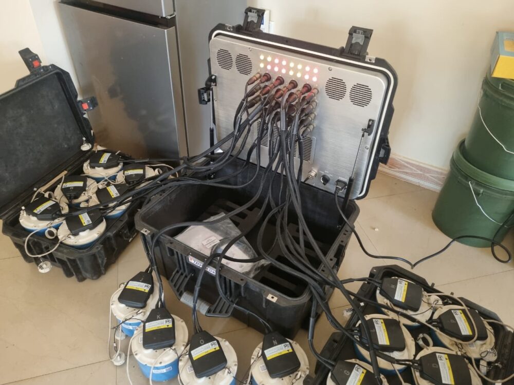
1. Survey Scope: The survey covered the entire 10,097,000 square meters of the Ore Gold Licence. A total of 1,690 data points were measured, with each point recording microseismic signals for at least six hours.
2. Data Collection: The microseismic signals were processed to create a 3D model of the subsurface, revealing the spatial distribution of seismic wave velocities down to a depth of 4.5 kilometers.
3. Data Interpretation: The results were visualized in the form of a layered depth distribution model, highlighting zones of reduced seismic wave velocities. These areas were interpreted as zones of increased fracturing and fluid movement, which are highly correlated with gold-bearing structures.
Key Findings
– Identification of Vertical Structures: The GEMS data revealed several vertical structures resembling magmatic roots, with wider zones near the surface. These structures are consistent with secondary magmatism, where fluid escapes toward the surface, potentially carrying gold deposits.
– Narrowed Exploration Focus: The 3D model allowed the team to pinpoint specific zones of interest for further exploration, significantly narrowing down the areas that require costly drilling. This improved both the accuracy and cost-effectiveness of the exploration efforts.
– Promising Zones for Drilling: The areas identified through GEMS are now prime candidates for targeted drilling, significantly reducing the amount of trial-and-error usually involved in gold exploration.
Outcome and Impact
By applying GEMS technology, the exploration team at the Ore Gold Licence site achieved several key outcomes:
– Cost Reduction: The ability to focus drilling efforts on promising areas has the potential to save millions of dollars in exploration costs.
– Environmental Sustainability: The passive nature of the GEMS method reduced the need for invasive drilling, minimizing the environmental footprint of the exploration project.
– Enhanced Accuracy: The detailed 3D model provided valuable insights into the subsurface, allowing for more informed decision-making and reducing the risk of unproductive drilling.
Conclusion
The application of GEMS technology at the Ore Gold Licence in Tanzania has proven to be a game-changer in gold exploration. By leveraging advanced geophysical methods, the exploration team was able to identify high-potential zones more accurately, reduce costs, and minimize environmental impact. This case study demonstrates how innovative technologies like GEMS can transform the way we approach resource exploration, making it more efficient, cost-effective, and sustainable.
As the next phase of exploration begins, which involves targeted drilling in the identified zones, the full potential of the Ore Gold Licence is yet to be realized. However, the success of the GEMS survey has already set a new standard for gold exploration in challenging environments.